Route Organizer for Multiple Stops: Pro Guide
Plan routes with multiple stops fast. Free, accurate steps for pros using a route organizer with multi-drop planning. Includes worked examples and tips.
GpsField
Field GIS Specialist · 11 min read
Route Organizer for Multiple Stops: Pro Guide
If you need a route organizer for multiple stops that’s fast and accurate, you can build, measure, and tidy up a multi‑drop plan right in GpsField’s free map workspace. Use the Distance and route measurement tool to add stops in order, refine bends for realistic driving distance, and save the result to a project—no signup required. This is a practical way to handle deliveries, inspections, farm runs, or property viewings without complex software. It also works well as a free multi drop route planner UK drivers can use for quick planning before they set off.
What a route organizer for multiple stops actually needs in the field
Pros usually need more than casual navigation. A reliable workflow lets you pre‑plan stops, measure total distance, tidy the sequence, check access on satellite view, and save routes for later edits or variants. For single‑driver days, this “plan‑measure‑reorder‑save” loop is often faster than heavyweight logistics systems.
There’s a difference between “maps with multiple stops” and full route optimization. A basic route planner with multiple stops and distances supports manual sequencing, simple reorders, and quick distance checks. Full optimization adds constraints (time windows, capacities, multiple vehicles, shifts). If you’re running one vehicle and just want the shortest practical path, manual sequencing is typically enough.
Distance accuracy depends on two things:
- The math: GpsField measures paths geodesically on the WGS‑84 ellipsoid (i.e., accounting for Earth’s curvature), which keeps long legs honest compared to flat‑plane approximations.
- Your points: Place stops where the vehicle actually drives (gates, site entrances), and add extra vertices where roads bend. A measurement is only as accurate as the points you use.
Quick start: plan a multi‑stop route in GpsField (free, no signup)
Use this as your practical GpsField checklist for a free multi drop route planner workflow.
- Open the Distance and route measurement tool
- Go to the GpsField Distance and route measurement.
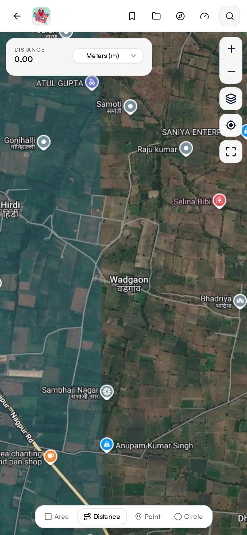 Screenshot of GpsField at https://gpsfield.com/workspace?mode=distance
- Search or pan to your area; choose a base map
- Zoom to your job area. Switch between satellite and map view to trace roads and confirm gates or field entrances.
- Add your start and stops in order
- Click to place your start point, then click each stop in planned order. The total length updates as you add points. This lets you set up driving directions with multiple stops for field work without leaving the map.
- Adjust the route to improve realism
- Add a point on long curves to better match the road centerline and measure multi‑stop delivery routes more accurately.
- To change the sequence, insert a stop between two points, or remove and re‑add a leg in your new order. You can drag points to fine‑tune their locations.
- Save and organize
- Save the measurement and place it in a project folder for future edits or variants. You can build a library of common runs in your Free map workspace (no signup).
Tip: Use Point marker / points of interest to pre‑mark frequent stops
If you revisit the same depots, tanks, gates, or sites, create markers once in Point marker / points of interest. On route‑planning days, zoom in and snap your route points to those markers to cut setup time and reduce mistakes.
Tip: Snap long legs with a midpoint marker when the road bends, for better distance estimates
A single straight segment over a curvy lane can under‑estimate travel distance. Add 1–2 intermediate points along the bends. The total will better match what you’ll actually drive.
Worked example 1: farm supply run with 12 drops (acres and miles shown)
Scenario: Start at the depot, then hit 12 fields for seed and chemical drops. The aim is a practical path that’s short, drivable, and respects field entrances. This workflow suits UK farm runs just as well—plan the sequence, then use your sat‑nav on A/B roads and local lanes.
- Build the initial sequence: Depot (Start) → Field A → Field B → … → Field L.
- On satellite view, place each stop at the field gate—not the field centroid—to reflect where the truck actually turns in.
- Visually reorder nearby fields to reduce backtracking. As you add or adjust points, watch the total update.
Result: After a quick tidy‑up of the sequence and a few added bend points, total distance drops from 46.9 mi (75.5 km) to 38.6 mi (62.1 km). Save as “South District 12‑drop — 2026‑10‑21” in your project folder for records.
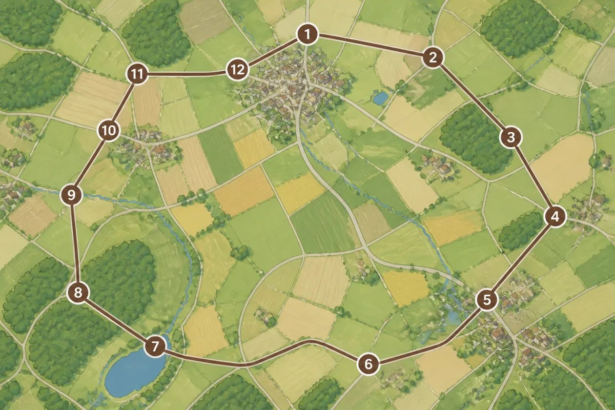 Illustration of a 12‑stop farm delivery route on a map
Unit check: switch between miles/km as needed
Teams often mix miles and kilometers. Keep both in play for hand‑offs: 1 mile ≈ 1.609 km. For acreage notes on paperwork, 1 hectare ≈ 2.471 acres; 10 hectares ≈ 24.71 acres. If you also measure field area for each stop, the polygon tool in the same workspace reports hectares, acres, and square metres/feet.
Accuracy note: refine bends with extra clicks near curves and gateways
Do not drop a stop on the middle of a field if you’ll access via a gate 200 m away. Place points on driveable entrances and add extra vertices along curved lanes. Your route planner with multiple stops and distances is only as accurate as these placements.
Worked example 2: civil site inspections—5 assets, time on site
Scenario: Inspect culverts C1–C5 with 20 minutes at each stop, driving mostly on secondary roads.
- Build the path: C1 → C2 → C3 → C4 → C5.
- Add vertices where roads bend. Confirm each stop is at a safe pull‑off, entrance, or layby on satellite view.
ETA planning example:
- Suppose the route measures 31.4 km total.
- If your average speed is 50 km/h: travel time ≈ 31.4 ÷ 50 = 0.628 h ≈ 38 minutes.
- Add dwell time: 5 stops × 20 minutes = 100 minutes.
- Total ≈ 38 + 100 = 138 minutes ≈ 2 h 18 min.
Save the route, then duplicate and try C1 → C3 → C2 → C4 → C5 if you anticipate a temporary lane closure; pick the shorter distance or the better access.
 Field inspection planning with multiple mapped stops
Tip: Add a marker at the site entrance, not the asset centroid, to reflect drivable access
Culverts, hydrants, and valves often sit off the carriageway. Place your route stop where you’ll park and walk in.
Tip: Keep a “rain day” variant avoiding unsealed tracks
In wet weather, copy your route and nudge stops to paved access points only. This approach to organizing multiple stops for site inspections avoids onsite surprises.
Worked example 3: real estate viewing route across town
Scenario: Office → 7 listings → Office. You want a fast, tidy loop for a 10 a.m.–2 p.m. viewing block. For UK estate agents, the same browser‑based process works—plan the loop in GpsField, then navigate with your preferred app on the day.
- Build the outbound sequence from the office to the seven listings.
- Add the office again as the final stop to close the loop.
- Duplicate the route, then reorder two adjacent listings to see if distance improves. Pick the shorter total and save it in a client‑named folder for next time.
If your addresses arrive as a mix of formats, use the Location and field utilities (address ↔ coordinates, elevation) to translate addresses to coordinates and place them precisely on the map. For coordinate‑heavy lists (UTM, MGRS, DMS, decimal), open the GPS and coordinate tools (UTM, MGRS, DMS).
Pro tips to cut miles and headaches with multiple stops
- Batch by zone first. Split your day north/central/south and work one zone at a time before sequencing. This trims long cross‑town legs in any multi drop route planner.
- Anchor the ends. Lock in depot/yard first and last, then tidy the middle.
- Avoid tight U‑turns for long vehicles. Route past and loop via a side road; it may add 0.2 mi but reduce risk and time. UK note: plan safe turning on A‑roads and consider one‑way systems in towns.
- Check gates and entrances on satellite view. Place stops where you’ll actually drive, not just at the parcel centroid.
- Keep seasonal variants. Build “winter roads” and “harvest traffic” versions for the same circuit and pick the right one on the day.
These habits make a free multi drop planning workflow punch above its weight, especially for single‑driver operations.
When do you need full route optimization software?
Use full optimization if you must honor time windows, driver shifts, vehicle capacities, or dispatch multiple vehicles with live tracking and proof‑of‑delivery. That’s beyond a simple multi‑stop map and measuring tool.
Otherwise, if your day looks like one driver with 6–20 stops and flexible timing, a free multi drop route planner that lets you measure, adjust the sequence, and save variants is often the fastest option.
Step‑by‑step: build a clean stop list from mixed data
- Unify inputs. If your list mixes addresses and coordinates, convert everything to one format using the GPS and coordinate tools (UTM, MGRS, DMS) or the Location and field utilities (address ↔ coordinates, elevation).
- Pre‑mark recurring places. Add depots, bulk tanks, gates, or key clients as permanent markers in the POI mode.
- Assemble the day’s route. In the Distance tool, click your start, then add stops in working order. Fine‑tune points on bends and confirm entrances in satellite view.
Tools you’ll use: GPS and coordinate tools (UTM, MGRS, DMS), Address ↔ Coordinates
If your crews share spreadsheets with assorted coordinate types, normalize them first. That keeps the process of planning directions with multiple stops smooth when you build routes on the map.
Store common routes in saved projects for reuse
Keep folders for “South District Drops,” “Quarterly Culvert Inspections,” and “Client‑X Viewings.” Duplicate and adjust as conditions change instead of rebuilding from scratch.
Try it now: plan and measure your next multi‑stop route
- Open the Distance and route measurement and drop your first five stops.
- Drag points to refine their exact positions, and add intermediate vertices on curves. Reorder by inserting a stop between legs or removing and re‑adding as needed to test sequences.
- Save, name it, and file it in a project. You’ve built a working multi‑stop route without any signup.
Frequently asked questions
Is there a free multi drop route planner that lets me add unlimited stops?
You can plan multi‑stop routes in GpsField’s Distance tool without creating an account. For very large lists, organize stops into logical legs (e.g., north zone, then south zone) to keep the map tidy and sequencing simple. If you also need time windows, capacities, or multi‑vehicle dispatch, consider dedicated optimization software. In the UK, the same browser‑based workflow applies.
Can I get driving directions with multiple stops and measure total distance on one map?
Yes—plan your path in GpsField to place multiple stops on maps and see the total distance update as you refine bends and entrances. It’s ideal for planning and documenting field work with multiple stops. For live turn‑by‑turn navigation, use your preferred navigation app alongside your saved route as reference. If you’re comparing options in the UK, try GpsField for planning and measurement, then navigate with the app you already trust.
Does GpsField auto‑optimize the order of my stops?
GpsField focuses on fast, manual sequencing: add, adjust, and save. It does not apply automatic vehicle‑routing optimization with constraints like time windows or capacities. For single‑driver runs, manual reordering while watching the total distance is usually sufficient and very quick.
What’s the best way to place stops for accurate distance on farm or site roads?
Place stops at real vehicle access points—gates, entrances, laybys—not at centroids. Add intermediate points along curves so the path follows the road you’ll drive. Remember that distance is computed geodesically on WGS‑84, but the practical accuracy still depends on careful point placement and clear aerial imagery.
Plan your next day now. Open the Distance tool and build a quick route with five stops to see how the total changes as you adjust: https://gpsfield.com/workspace?mode=distance
Tags & Topics